piątek, 9 sierpnia 2013

EasyStreetView for MeeGo, Symbian and BB10

EasyStreetView is a Google Maps client for Qt-based smartphone platforms (MeeGo Harmattan, Symbian, BlackBerry Z10, Sailfish OS), focused on, and optimized for, quick and convenient StreetView usage. Easy to use, small (only 30 kB!) and fast.

Unlike in other clients, you don't have to switch back and forth between the map and the street view if you want to change location, no need to drag and drop the Pegman, either.

This application provides both the map and the street view on one screen. Simply enter an address to find the desired location and show it on a map, then just tap on a street/place you want to see and... that's it - a marker will be shown on the map and street view will be displayed.


The map and street view are integrated with each other - you can switch to a different street anytime just by tapping on different area on the map and street view will change instantly. As you move on the street view, the marker moves on the map, too, always showing you the current, exact location. At the bottom of the screen, on the task bar, you can always see current location's coordinates (latitude and longitude) and current heading (direction you're facing on the street view). The map and street view can be zoomed in/out, panned and rotated independently. You can switch the map between street and satellite view.


Obviously, this application can show the street view only for locations which street view imagery exists for. If you tap on a street or place where street view panorama is not available from Google, the marker will not be shown and a short vibration feedback will be generated to let you know that this location isn't Street View enabled.

EasyStreetView uses Google's Geocoding service to translate addresses into map locations, and Google Maps / StreetView APIs to show the map and street view. It requires Interent connection. The program supports both portrait and landscape orientation.


Reviews: AllAboutSymbian


MeeGo Harmattan (Nokia N9 / N950) version: http://store.ovi.com/content/386876


Symbian Anna & Belle version: http://store.ovi.com/content/388042

BlackBerry BB10 version: http://appworld.blackberry.com/webstore/content/36957888/

piątek, 26 lipca 2013

ISSTracker for Harmattan (N9 / N950) and Symbian

ISSTracker is an application to track satellites and predict their visible night time passes over user's location.

It supports the ISS (International Space Station / Zarya), Hubble Space Telescope, and any other satellite (out of hundreds listed at CelesTrak.com) defined by the user.


The ISS is an especially interesting object for sky watchers because (in favorable conditions) its visual brightness reaches -4 mag., i.e. much brighter than the brightest star Sirius, and often even brighter than Venus (even by 8 to 16 times when it produces flares as sunlight glints off its reflective surfaces). So it often becomes the third brightest object in our sky, after the Sun and the Moon.  The ISS orbits the Earth at very high speed so it passes over one's location many times a day, but it is visible only in certain conditions: when the sky is dark enough not to outshine it, and the Sun is not too low under the horizon for its light to reach the ISS and get reflected by it. This means that the ISS can be seen only shortly after the sunset or before the sunrise. And it only takes several minutes (usually between 1 and 10) for it to cross the sky and disappear.

This program predicts visible passes of ISS, HST and any other satellite. It calculates and displays dates and times of approach, visibility duration, and azimuths and elevations of approach, transit and departure (i.e. where the satellite becomes visible, where it disappears and what is its higest elevation).


For each satellite the program shows (and updates every 3 seconds) on Nokia Maps its current position and where it will be within the next hour (in 5-minute steps). The map can be zoomed in/out from world map to street level, and map imagery can be selected from street, terrain and satellite.

In addition to ISS and HST, the user can add any other satellite out of hundreds of satellites listed at CelesTrak.com. Adding a satellite only takes entering its name and the name of file containing its orbit data (as listed on CelesTrak).


The program automatically downloads and saves current orbit data from CelesTrak, which assures the highest precision. User location can be obtained from the GPS receiver or entered manually.

Reviews: AllAboutSymbian

MeeGo Harmattan (Nokia N9 / N950) version: http://store.ovi.com/content/385020

Symbian Anna & Belle version: http://store.ovi.com/content/385635

piątek, 5 lipca 2013

StarFinder ported to BlackBerry BB10 (Z10)

StarFinder has been ported to BlackBerry BB10 OS (for the Z10 phone). For detailed description of StarFinder please see here and here.

http://appworld.blackberry.com/webstore/content/31643888/


Some screenshots of the BB10 version follow:


wtorek, 25 czerwca 2013

GeoCoder for Harmattan (N9 / N950) and Symbian

The main purpose of GeoCoder is to let quickly and easily find any location and provide LOTS of information about it, that would otherwise require using multiple, separate resources.

The application accepts as input any kind of data pointing to the location you want to find:

- its address (full or partial, e.g. just Champs Elysees) or place name (e.g. Tate Gallery), or
- its coordinates (in either decimal or DMS format), or
- selecting its location on a map.

Just select the corresponding input type from the top most button row ("Address" or "Coords" or "Map"), enter the data and click "OK".

For an address, it is not necessary to enter all details. City name (if it is unique) or place name (e.g. Niagara falls) is usually sufficient. However, the more data you enter the more precise result you will get. Entering full address with street number will give you precision of the results of up to several meters...


Within just a few seconds you will get A LOT of information about the location, including:

- location shown on Nokia Map (can be switched between Street, Terrain, Satellite)
- exact GPS coordinates (in both decimal and DMS format)
- exact elevation above the mean sea level (in meters and feet)
- detailed address (country, city, street & number, district, county, state)
- postal code
- time zone name and UTC difference
- daylight saving (summer) time enabled or not, difference
- current time and date
- sunrise & sunset times and day length
- dawn & dusk times and daylight duration
- moonrise & moonset times
- current weather (description, cloudiness, temperature, pressure, humidity, wind speed, direction and gust, precipitation (rain / snow)
- road distance from your home location (configured in Settings) or your current location (from the GPS receiver) in kilometers and miles
- travel time (for driving, bicycling or walking - configurable in Settings) from your home or current location.


Additionally, for every location you also get:

- a 360 degree panorama picture of the exact location (if available for that location from Google Street View Image API)
- 7-day weather prediction
- full screen Google Map (street and satellite) and Google Street View
- direct link to a Wikipedia article about the city in which the location is placed, useful if you'd like to check some more advanced details like e.g. population, density, history, etc.


In addition to the above, GeoCoder also provides a "HERE" option, which simply shows all the above listed data for the user's current location obtained from the GPS receiver. All it takes is to select the "Here" tab and press "Get" button. A nice way to quickly get A LOT of information about your current location, including exact elevation, postal code, distance and travel time to/from home, sunrise/sunset, and all the rest.


 Benefits:
- with just one tap (and a few seconds of waiting) you get A LOT of information about any location worldwide, which otherwise need checking at least several separate resources (at least I am not aware of any service providing them all)
- very quick and easy way to get a panorama imagery of a location. Just input data to find the location and then tap on the Panorama button. No need to browse maps, drag and drop the Pegman, etc.
- both Nokia Maps and Google Maps (with Street View) are provided
- small (240 kB ) and fast.

The program uses Nokia and Google geocoding and reverse geocoding services, Nokia and Google routing services, Google Elevation API, Google TimeZone API, Google StreetView Image API, Google Maps API, OpenWeatherMap API, and more. It requires Internet connection.

MeeGo Harmattan version: http://store.ovi.com/content/379830

Symbian Anna & Belle version: http://store.ovi.com/content/381250

niedziela, 19 maja 2013

MoonCalc Pro ported to Sailfish OS

Now available for Jolla's new Sailfish OS is also MoonCalc Pro, just ported from Harmattan.  So now we have FOUR applications ready for launch for the Sailfish OS, and two more coming within the next week or two. Who has more? :-)

P.S. Some further visual tweaks and improvements will be applied once I can get hold of a Sailfish OS device and test the apps on real hardware.


StarFinder Pro ported to Jolla's Sailfish OS

StarFinder Pro is another port from Harmattan to Jolla's new Sailfish OS. See earlier posts for full description of this application.


Biorhythms Pro ported to Jolla's Sailfish OS

Biorhythms Pro (full description can be found in earlier posts) has just been ported to Jolla's upcoming Sailfish OS. Some screenshots follow:


wtorek, 9 kwietnia 2013

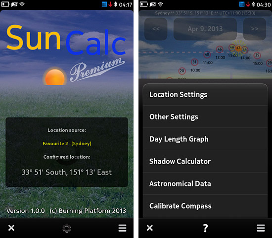
SunCalc PREMIUM for the Nokia N9 & N950

SunCalc PREMIUM is a *much* enhanced and improved version of SunCalc, with lots of new functions and many improvements to the existing ones.


First of all, in addition to location obtained from the GPS receiver, SunCalc Premium now supports storing up to three favourite locations and quickly switching between them. Each location can be given a name so that it can be easily distinguished.

Location coordinates can not only be entered manually like in SunCalc, but now also quickly and easily selected on a map. The application uses Nokia Maps, so for this it needs Internet connection. If one doesn't want to connect to the Internet, coordinates can still be entered manually for each location, like in SunCalc.

For each location the user can also select its time zone. If correct time zone is set the graph and all data will be shown in the time of the destination. (Note: currently there is no separate setting for Daylight saving time, so the selected time zone value should reflect whether DST is enabled or not in the selected location. In other words, if the standard time zone of some location is e.g. UTC - 5 hours but DST is enabled, one should select UTC - 4 hours).

For each location (and for the GPS receiver) also another new option can be set up: Altitude Limit. Using this option the user can configure a Sun altitude to be monitored - the program will show when the Sun goes above and below the selected altitude and how long it stays above it each day.


A new "Other Settings" window has been added with two advanced options:

- "Day / Night length" option lets the user decide how to calculate the length of day and night - either based on sunrise/sunset or dawn/dusk (the latter more closely reflects when the sky starts or stops being illuminated by the Sun). Setting this option affects all day and night length calculations of the program shown in the data window on its main screen.

- "Sunrise / Sunset time calculated for" - this option allows choosing the part of Sun's disc to be used for calculating the moment of sunrise and sunset. The user can choose between the moment when the center of Sun's disc is at the horizon line, or when its upper limb touches the mathematical horizon, and both these options in two variants: with or without atmospheric refraction accounted for.


SunCalc Premium has a new screen: Day Length Graph. This function shows a graph presenting day length (both from sunrise to sunset and from dawn to dusk), as well as night length, for the entire year, on one screen. The graph is interactive - tap on it to get detailed day/night length data for the selected day. If you're planning a trip or vacations - with this graph you can quickly find the part of year to get the most daylight and the longest days for your stay. Many people don't realize that when it is summer and days are long in one hemisphere it is winder and days are the shortest in the other hemisphere. This graph will clearly show it, for any location on Earth.


Another new option is the Shadow length and angle calculator. For any selected location (and any selected time) it quickly calculates the length and direction of shadows. All you need to enter is the height of an object whose shadow you want to calculate. In addition to displaying the shadow length and angle values, a sun/shadow compass is also displayed showing the azimuths. This option may be useful for photographers.

Finally, there is also a new screen providing real time calculations of Sun-related astronomical data like azimuth, elevation, visual and absolute magnitude, apparent size, distance (in AU and km), right ascension, declination, hour angle, ecliptic latitude and longitude, and more. Some other 'fixed' Sun data (like orbital/rotational periods, orbital speed, gravity, density, spectral type, radius, etc.) is also shown.


Back to the main screen, which also includes many changes and improvements.

For each hour (inside of the red circles) Sun's elevation (altitude) at that hour is now shown. In addition to this, right below the horizon line, for each hour also the Sun's azimuth at that hour is now displayed.

If the smallest data window size is selected, the Sun Compass is shown. If today's date is selected, the compass shows the Sun's current azimuth, so just turn in the direction shown by the Sun icon on the compass to see the Sun. What's more, using the aforementioned Sun's altitude and azimuth data shown for each hour, you can also use the compass to quickly check where exactly in the sky the Sun will be at any other hour or day.

Double tap the default small compass to show its bigger full screen version.


At the top of the main screen (and the other above mentioned screens) the application shows the name, coordinates and time zone / local time of the currently selected favourite location.

The graph now also supports the earlier described Altitude Limit option configurable in Location settings for each location. The selected altitude to be monitored is shown on the graph using a pink dashed line making it easy to see if and when the Sun reaches it and how long it stays above it. Additionally, in the data window the program displays exact times at which the Sun crosses the configured altitude limit and the duration of its stay above that altitude.

The current position of the Sun is now more clearly distinguishable thanks to animated (rotating) sunrays surrounding the Sun's orange disc.


As the application now uses phone's magnetometer sensor, it now also contains a sensor calibration function. You don't need to look at the display while rotating the phone to check when it is fully calibrated - once the calibration is 100% you will be notified about it with a short vibration. The same way the program will notify you if the sensor is calibrated when you launch the application - if there is no short vibration on the title screen it means that the sensor isn't fully calibrated and you should calibrate it to ensure correct compass readings.

Each function has a detailed help (separately for each screen) available via the "?" buton on the task bar, explaining each option of the program and the most important terms and data related to the Sun.
The application also has some performance improvements and code optimizations - it works faster and smoother. Thanks to disabling timers when they aren't needed the program should also consume less power.

SunCalc Premium is now available from the Nokia Store:

http://store.ovi.com/content/363612

czwartek, 28 lutego 2013

sobota, 16 lutego 2013

Biorhythms Pro for MeeGo, Symbian and BB10


Probably the oldest Biorhythm calculation app for smartphones (written in early 2002 for the Nokia 9210 Communicator) now ported to MeeGo Harmattan (Nokia N9 / N950), Symbian Anna/Belle, BlackBerry BB10 and Sailfish OS. Provides features missing from other apps of this kind: storing data of two persons and quickly switching between them, biorhythm interpretation, warning about critical days, scrollable graph, information about cycles (completed, day of current cycle, etc.) and more. Accurate and easy to use.


Its main screen is divided into three parts: buttons to select person, detailed biorhythm levels for the selected day (with some additional information like the number of completed cycles, day of current cycle, whether the biorhythm is currently rising or falling, etc.) and a scrollable graph.


Interpretation of the current biorhythm reading is available via the "Interpret" button. The program also contains a help page informing how to use the application, and a history and explanation of the biorhythm theory.

Reviews: AllAboutSymbian


MeeGo Harmattan (Nokia N9 & N950) version:  http://store.ovi.com/content/348910

Symbian Anna & Belle version: http://store.ovi.com/content/353043

BlackBerry BB10 version: http://appworld.blackberry.com/webstore/content/28025187/

Jolla (Sailfish OS) version is also ready for release.