wtorek, 9 kwietnia 2013

SunCalc PREMIUM for the Nokia N9 & N950

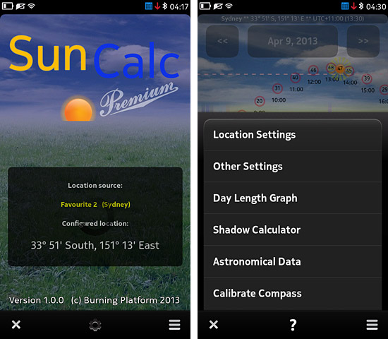
SunCalc PREMIUM is a *much* enhanced and improved version of SunCalc, with lots of new functions and many improvements to the existing ones.


First of all, in addition to location obtained from the GPS receiver, SunCalc Premium now supports storing up to three favourite locations and quickly switching between them. Each location can be given a name so that it can be easily distinguished.

Location coordinates can not only be entered manually like in SunCalc, but now also quickly and easily selected on a map. The application uses Nokia Maps, so for this it needs Internet connection. If one doesn't want to connect to the Internet, coordinates can still be entered manually for each location, like in SunCalc.

For each location the user can also select its time zone. If correct time zone is set the graph and all data will be shown in the time of the destination. (Note: currently there is no separate setting for Daylight saving time, so the selected time zone value should reflect whether DST is enabled or not in the selected location. In other words, if the standard time zone of some location is e.g. UTC - 5 hours but DST is enabled, one should select UTC - 4 hours).

For each location (and for the GPS receiver) also another new option can be set up: Altitude Limit. Using this option the user can configure a Sun altitude to be monitored - the program will show when the Sun goes above and below the selected altitude and how long it stays above it each day.


A new "Other Settings" window has been added with two advanced options:

- "Day / Night length" option lets the user decide how to calculate the length of day and night - either based on sunrise/sunset or dawn/dusk (the latter more closely reflects when the sky starts or stops being illuminated by the Sun). Setting this option affects all day and night length calculations of the program shown in the data window on its main screen.

- "Sunrise / Sunset time calculated for" - this option allows choosing the part of Sun's disc to be used for calculating the moment of sunrise and sunset. The user can choose between the moment when the center of Sun's disc is at the horizon line, or when its upper limb touches the mathematical horizon, and both these options in two variants: with or without atmospheric refraction accounted for.


SunCalc Premium has a new screen: Day Length Graph. This function shows a graph presenting day length (both from sunrise to sunset and from dawn to dusk), as well as night length, for the entire year, on one screen. The graph is interactive - tap on it to get detailed day/night length data for the selected day. If you're planning a trip or vacations - with this graph you can quickly find the part of year to get the most daylight and the longest days for your stay. Many people don't realize that when it is summer and days are long in one hemisphere it is winder and days are the shortest in the other hemisphere. This graph will clearly show it, for any location on Earth.


Another new option is the Shadow length and angle calculator. For any selected location (and any selected time) it quickly calculates the length and direction of shadows. All you need to enter is the height of an object whose shadow you want to calculate. In addition to displaying the shadow length and angle values, a sun/shadow compass is also displayed showing the azimuths. This option may be useful for photographers.

Finally, there is also a new screen providing real time calculations of Sun-related astronomical data like azimuth, elevation, visual and absolute magnitude, apparent size, distance (in AU and km), right ascension, declination, hour angle, ecliptic latitude and longitude, and more. Some other 'fixed' Sun data (like orbital/rotational periods, orbital speed, gravity, density, spectral type, radius, etc.) is also shown.


Back to the main screen, which also includes many changes and improvements.

For each hour (inside of the red circles) Sun's elevation (altitude) at that hour is now shown. In addition to this, right below the horizon line, for each hour also the Sun's azimuth at that hour is now displayed.

If the smallest data window size is selected, the Sun Compass is shown. If today's date is selected, the compass shows the Sun's current azimuth, so just turn in the direction shown by the Sun icon on the compass to see the Sun. What's more, using the aforementioned Sun's altitude and azimuth data shown for each hour, you can also use the compass to quickly check where exactly in the sky the Sun will be at any other hour or day.

Double tap the default small compass to show its bigger full screen version.


At the top of the main screen (and the other above mentioned screens) the application shows the name, coordinates and time zone / local time of the currently selected favourite location.

The graph now also supports the earlier described Altitude Limit option configurable in Location settings for each location. The selected altitude to be monitored is shown on the graph using a pink dashed line making it easy to see if and when the Sun reaches it and how long it stays above it. Additionally, in the data window the program displays exact times at which the Sun crosses the configured altitude limit and the duration of its stay above that altitude.

The current position of the Sun is now more clearly distinguishable thanks to animated (rotating) sunrays surrounding the Sun's orange disc.


As the application now uses phone's magnetometer sensor, it now also contains a sensor calibration function. You don't need to look at the display while rotating the phone to check when it is fully calibrated - once the calibration is 100% you will be notified about it with a short vibration. The same way the program will notify you if the sensor is calibrated when you launch the application - if there is no short vibration on the title screen it means that the sensor isn't fully calibrated and you should calibrate it to ensure correct compass readings.

Each function has a detailed help (separately for each screen) available via the "?" buton on the task bar, explaining each option of the program and the most important terms and data related to the Sun.
The application also has some performance improvements and code optimizations - it works faster and smoother. Thanks to disabling timers when they aren't needed the program should also consume less power.

SunCalc Premium is now available from the Nokia Store:

http://store.ovi.com/content/363612

czwartek, 28 lutego 2013

sobota, 16 lutego 2013

Biorhythms Pro for MeeGo, Symbian and BB10


Probably the oldest Biorhythm calculation app for smartphones (written in early 2002 for the Nokia 9210 Communicator) now ported to MeeGo Harmattan (Nokia N9 / N950), Symbian Anna/Belle, BlackBerry BB10 and Sailfish OS. Provides features missing from other apps of this kind: storing data of two persons and quickly switching between them, biorhythm interpretation, warning about critical days, scrollable graph, information about cycles (completed, day of current cycle, etc.) and more. Accurate and easy to use.


Its main screen is divided into three parts: buttons to select person, detailed biorhythm levels for the selected day (with some additional information like the number of completed cycles, day of current cycle, whether the biorhythm is currently rising or falling, etc.) and a scrollable graph.


Interpretation of the current biorhythm reading is available via the "Interpret" button. The program also contains a help page informing how to use the application, and a history and explanation of the biorhythm theory.

Reviews: AllAboutSymbian


MeeGo Harmattan (Nokia N9 & N950) version:  http://store.ovi.com/content/348910

Symbian Anna & Belle version: http://store.ovi.com/content/353043

BlackBerry BB10 version: http://appworld.blackberry.com/webstore/content/28025187/

Jolla (Sailfish OS) version is also ready for release.

niedziela, 18 listopada 2012

SunCalc for Harmattan (Nokia N9 & N950) and Symbian

SunCalc provides all important information related to the Sun's appearance in your local sky, for any geographic location and any date.

See at a glance on the real-time updated graph how the path of the Sun changes through the year and where the Sun is now, in the next couple of hours, tomorrow or on any other day. For any date and location get exact times of sunrise and sunset, dawn and dusk, civil, nautical, amateur and astronomical twilight starts and ends, the time of transit and its elevation (altitude), day and night length (also compared to the previous day and solstice), date of day of the same length, and more.


SunCalc supports either manually entered geographic coordinates or it can get them automatically from the GPS receiver of your smartphone.

Unlike other applications of this type usually only calculating sunrise and sunset times, SunCalc will keep you informed about various twilight levels (e.g. the start of civil twilight is when it is no longer possible to read outside without artificial illumination, or the start of astronomical twilight is when the sky gets completely dark, without any sun light reaching it from below the horizon), and also about the exact time of transit and its elevation, which is when the Sun reaches the highest altitude in the sky on a selected day. You can use it to quickly check how the day and night lengths change between different seasons and compared to the longest or shortest day of the year (the solstice day), how long the Sun stays above or below the horizon, how low under the horizon it goes during the night, and more.


Providing such a detailed and exact information presented both numerically and on the real-time calculated graph, SunCalc will help you to plan your daily activities depending on daylight and darkness as thanks to it you will know when exactly it gets dark or when the first sun rays will start lighting up the sky. Advanced users may find it helpful for many other uses, e.g. to position solar panels at an angle matching the Sun's elevation to get the most of its radiation.

The application provides several different data window sizes (double-tap to switch between them; the chosen size is remembered), scrollable graph, and a built-in help explaining all the supported types of data and terms used.


Reviews: AllAboutSymbian

SunCalc is now available for Harmattan (the Nokia N9 and N950) and for Symbian Anna & Belle on the Nokia Ovi Store:

Harmattan version: http://store.ovi.com/content/330378

Symbian version: http://store.ovi.com/content/338208

czwartek, 30 sierpnia 2012

StarFinder 2.0 now with Solar System support

New version 2.0 of StarFinder has been released for MeeGo Harmattan phones (the Nokia N9 and N950), Symbian Anna/Belle and BlackBerry Z10. In addition to all features of the first version (described below) it brings support for Solar System objects (tracking and locating all planets + Pluto, the Sun and the Moon) and real time calculation of a range of useful astronomical data for all supported objects, such as:

apparent magnitude, apparent diameter, distance from the Earth and from the Sun, phase / illumination, hour angle, right ascension and declination, elongation, phase angle. Many other important details are also provided, including: orbital period, rotation period, orbit eccentricity, axial tilt, orbit inclination, mean radius, surface gravity, mean density, and more.

For all supported objects (stars, constellations, deep sky objects, planets, etc.) the application now also calculates their rise, set and transit times, as well as transit altitude.


MeeGo Harmattan version: http://store.ovi.com/content/294729

Symbian version: http://store.ovi.com/content/302381

BlackBerry BB10 version: http://appworld.blackberry.com/webstore/content/31643888/

środa, 27 czerwca 2012

StarFinder for MeeGo (Nokia N9 & N950) and Symbian

Easily locate stars, constellations, planets, galaxies, nebulae, star clusters, asterisms, meteor shower radiants.

Just select the object of your interest and the program will instantly show you where in the sky it is located. Turn in the direction and look at the altitude shown and... there you have it!

You've heard so many times about Sirius or Vega, or the Pleiades or Hyades, or M31 Andromeda Galaxy, or the Gemini constellation, but you were never able to find them or it's been always taking you a lot of time?  Now it's as easy as one tap!

This version of StarFinder supports all 88 constellations, 72 brightest stars, 21 brightest Messier objects (all visible with the naked eye, i.e. up to +6th apparent magnitude), 20 most popular asterisms, and 26 meteor shower radiants.  For each object useful information is provided, such as coordinates (right ascension and declination), constellation, Bayer/Messier/NGC designation, distance from Earth, apparent and absolute magnitude, visibility (latitudes at which the object can be seen), occurence and intensity (in case of meteor showers), and also a short description and a direct one-tap link to related Mobile Wikipedia article, should you need more details. The application also calculates rise/set and transit times for all objects, and for Solar system bodies (planets, the Sun, the Moon) additionally a rich selection of real time orbit data.

Supports both GPS and manually entered geographic coordinates. Uses magnetometer sensor and orientation sensor along with precise calculation algorithm to track positions of sky objects for any geographic location at any time.

** On MeeGo Harmattan, requires PR1.1 or newer. Doesn't work on the obsolete PR1.0 - please update your phone.   On Symbian, works on all Symbian^3, Anna and Belle phones with nHD screens and magnetometer sensors. On BlackBerry 10 it is currently available for the Z10 phone.


MeeGo version: http://store.ovi.com/content/294729

Symbian version:  http://store.ovi.com/content/302381

BlackBerry 10 version: http://appworld.blackberry.com/webstore/content/31643888/

czwartek, 29 marca 2012

MoonCalc for MeeGo (Nokia N9 & N950) and Symbian

Advanced Moon tool for the Nokia N9 & N950 and Symbian ^3 / Anna / Belle (now also available for the BlackBerry BB10 and Sailfish OS). Provides rich, real time calculations of Moon phase, age, illumination, distance, apparent size, coordinates (right ascension, declination, ecliptic latitude and longitude), azimuth, elevation, moonrise and moonset times, perigees and apogees, Moon Compass, and more. Supports both GPS and manually entered geographic location coordinates. Daily view shows all current data (as well as for any other selected date and location), monthly view displays summary of phases and illuminations in the current (or any other selected) month, "Perigees and Apogees" and "New and Full Moons" show lists of all corresponding events in a selected year, the Moon Compass lets one rapidly find the Moon on the sky just by looking in the direction (and altitude) shown. New "Moon Path" screen shows an interactive graph presenting Moon's path over your local sky for any date and location. Built-in help pages explain all terms and data provided by the application.


Reviews: AllBoutN9


Symbian version: http://store.ovi.com/content/270596

BlackBerry BB10 version: http://appworld.blackberry.com/webstore/content/28025177/